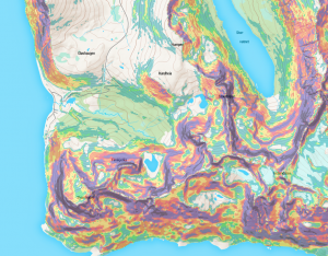
This image shows how the slope layer partnered with Rewindr Terrain map is a powerful tool in visualizing mountain environments
How to use and read the Rewindr slope layer?
The slope layer is available in selected countries and regions. It’s purpose is to help as a tool in finding safe ascent and descent lines in mountain environments. It should not be considered as an absolute truth as it is generated from digital environment model (DEM) data that is either generated from satellite measurements or LiDAR (Light Detection and Ranging, measuring distance to a target by illuminating the target with laser light) and is therefore not 100% accurate. It should only be used as a guide and decisions in back country should always be based on actual weather conditions, local knowledge and risk assessment. If you are unsure of the local conditions, hire a guide.
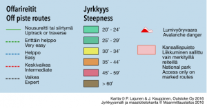
The colors in the slope layer represent the slope angle in a certain spot. Clear and green colored areas are slopes where the gradient is under 25 degrees. These areas are considered places, where natural avalanches are unlikely. It is important to note that, even if you are on an area that is “green” or “clear” the area still might be an avalanche runout zone, so it is necessary to look at other aspects than the actual slope to determine the risk. Always check local weather conditions and avalanche risk scale before going to backcountry! Wind and temperature affect the snow pack and that is something that cannot be calculated with software.
When avalanche risk is medium to high (3 or greater on a scale from 0-5) it is advised to completely avoid areas marked yellow to purple. Also pay attention to what kind of terrain lies up from so called safe areas. Watch out for steep slopes directly above, cornices and gullies.
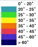
The colors represent the calculated degrees of the slope. Actual degrees might differ for the model, so use only as a guide and tool. Always make decisions based on actual weather and local conditions!


Recent Comments